Difference between revisions of "Image Classification Tutorial using Orfeo Toolbox"
| Line 14: | Line 14: | ||
===Data Access=== |
===Data Access=== |
||
{| border="1" cellpadding="5" cellspacing="0" |
|||
|+'''Data Sets Used''' |
|||
|- |
|||
! style="background:#efefef;" | Dataset |
|||
! style="background:#ffdead;" | Data Type |
|||
! style="background:#efefef;" | Source |
|||
|- |
|||
| Government Radiometrics Survey |
|||
| CSV from source, Provided as *.shp |
|||
| [http://gdrdap.agg.nrcan.gc.ca/geodap/index_e.html Geoscience Data Repository for ESS Geophysical and Geochemical Data] |
|||
|- |
|||
| Sample Sites |
|||
| *.shp |
|||
| Created Independently |
|||
|- |
|||
| Streams |
|||
| *.shp |
|||
| [http://www.geobase.ca/geobase/en/browse.do?produit=nhn&decoupage=units&map=021H GeoBase] |
|||
|- |
|||
| Claim Outline |
|||
| *.shp |
|||
| Created Independently |
|||
|- |
|||
| style="border-bottom:3px solid grey;" | DEM |
|||
| style="border-bottom:3px solid grey;" | *.dem |
|||
| style="border-bottom:3px solid grey;" | [http://www.geobase.ca/geobase/en/download.do?produit=cded&items=official%2fcded%2f50k_dem%2f021%2f021h15.zip&protocol=http GeoBase ], western portion of DEM only. |
|||
|} |
|||
<br> |
|||
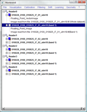
[[image:fig1.png|thumb|Orfeo Toolbox GUI]] |
[[image:fig1.png|thumb|Orfeo Toolbox GUI]] |
||
Revision as of 15:29, 3 December 2010
Contents
Disclaimer
The information contained in this wiki is part of a project deliverable for a 4000 level Geomatics course at Carleton University. Information pertaining to software tools and parameters may be different depending on your application and software version. Landsat imagery was used in this tutorial however other image sources may be used to conduct this tutorial. Geospatial processing time may vary depending on computer configuration and size of data used.
Introduction
A fundamental aspect of image interpretation and analysis is the classification of land features in order to produce land cover maps. Typically produced using satellite imagery, classification is the process of sorting image pixels of unknown identity into groups based on points of known identity (Davidson, 2010). The user attempts to classify various features and/or land cover classes of interest using visual interpretation to group homogeneous pixels to create a thematic map (Canada Centre for Remote Sensing, 2008). Classification procedures can be broken into two categories based on the method used. Unsupervised classification, which determines natural statistical groupings within multispectral data based on the separations between means, is often used when little is known about the study area. Spectral classes are determined using statistical information followed by the user matching the classes to the land covers. Several algorithms can be employed to perform an unsupervised classification to determine the natural pixel groupings in the image. Supervised classification which can be seen as the reverse of unsupervised classification, involves the selection of land cover groupings to be mapped in combination with the delineation of training pixels for each class, the user has greater control over the procedure and has input on every step of the classification process compared to the unsupervised classification method. Once the training areas are delineated, a classifier such as maximum likelihood is used to assign all unknown pixels to the class whose training data they resemble most. The purpose of this tutorial is to emulate the supervised classification procedure using Orfeo Toolbox (OTB) and export the classification results in order to create thematic maps.
Background
This tutorial is conducted using Orfeo Toolbox. Orfeo Toolbox is an open source remote sensing image processing software with a goal of facilitating the development of new algorithms and validation procedures. It is a multiplatform, free to use software with a C++ library containing a multitude of pre-processing and image analysis algorithms. The graphical user interface or GUI provides non programmers with the ability to visually comprehend and analyze the procedures as well as interact with the available parameters. By including several well known algorithms and tools for free, OTB encourages research by stressing the importance of understanding how algorithms work, as their slogan puts it, OTB is not a black box (Orfeo Toolbox, 2010). OTB offers functionalities for remote sensing image processing such as but not limited to image filtering, feature extraction, change detection and classification.
Objective
In this tutorial you will learn how to apply your existing remote sensing skills to generate land-cover data using a supervised classification procedure in order to display the results in Google Earth using a combination of OTB and Quantum GIS (QGIS) with the Grass plugin. The final outcome is a KML file containing the land-cover polygons extracted from the supervised classification. Free and open source software and freely available Landsat imagery will be used to demonstrate an image classification application without using proprietary software.
Method
Data Access
| Dataset | Data Type | Source |
|---|---|---|
| Government Radiometrics Survey | CSV from source, Provided as *.shp | Geoscience Data Repository for ESS Geophysical and Geochemical Data |
| Sample Sites | *.shp | Created Independently |
| Streams | *.shp | GeoBase |
| Claim Outline | *.shp | Created Independently |
| DEM | *.dem | GeoBase , western portion of DEM only. |
Orfeo Toolbox
Installation
View Bands in RGB
Create your Area of Interest
Clustering
Image Classification
Quantum GIS
Image Filter and Data Export
Conclusion
References
Davidson, A. (2010). A Davidson's slides on Image Classification. GEOM 4003: Remote Sensing of the Environment.
Orfeo Toolbox. (2010). Orfeo Toolbox is not a black box.. Retrieved November 19, 2010 from http://www.orfeo-toolbox.org/otb/
Tutorial: Fundamentals of Remote Sensing Image interpretations & analysis - Image Classification. (2008). Canada Centre for Remote Sensing. Retreived November 19, 2010 from http://www.ccrs.nrcan.gc.ca/resource/tutor/fundam/chapter4/07_e.php
Zhang, R. & Ma, J. (2008). An improved SVM method P-SVM for classification of remotely sensed data. International Journal of Remote Sensing 29, 6029-6036
Related Links
- Orfeo Toolbox Web site
- Orfeo Toolbox Wiki
- Quantum GIS Web site
- Quantum GIS Wiki
- Grass GIS Web site
- Grass GIS Wiki
- Geobase Web site
- Geobase Wiki
- Google Earth Web site
- Google Earth Wiki
