Difference between revisions of "Unsupervised Classification using Google Earth Engine"
JulienBelair (talk | contribs) |
JulienBelair (talk | contribs) |
||
| Line 1: | Line 1: | ||
==Introduction== |
==Introduction== |
||
| − | [[File:Google Earth Engine Logo.png|thumb|Google Earth Engine]] |
+ | [[File:Google Earth Engine Logo.png|200px|thumb|Google Earth Engine]] |
| + | [[File:2geesignup.png|150px|thumb|right|Google Earth Engine Sign Up Page]] |
||
Google Earth Engine is a cloud-based open source platform for satellite imagery and geospatial data analysis. It allows users to access, visualize, and analyze large-scale datasets of satellite and aerial imagery, providing tools for researching and monitoring the earth's resources and changes over time. With its vast collection of data and powerful analysis tools, Earth Engine enables users to gain insights and make data-driven decisions on a global scale. <br> |
Google Earth Engine is a cloud-based open source platform for satellite imagery and geospatial data analysis. It allows users to access, visualize, and analyze large-scale datasets of satellite and aerial imagery, providing tools for researching and monitoring the earth's resources and changes over time. With its vast collection of data and powerful analysis tools, Earth Engine enables users to gain insights and make data-driven decisions on a global scale. <br> |
||
| Line 6: | Line 7: | ||
Unsupervised classification is a type of machine learning technique that is used to classify data without any pre-existing labels. Unlike supervised classification, which uses labeled data to train the model, unsupervised classification relies on the inherent structure of the data itself to identify patterns and relationships within the data. This allows the model to learn from the data without any human intervention, making it a powerful tool for exploring and analyzing large, complex datasets. Despite its potential, unsupervised classification is not without its challenges, including the need for large amounts of data and the difficulty in interpreting the results of the classification. Overall, unsupervised classification is a valuable tool for uncovering hidden patterns and relationships within data.<br> |
Unsupervised classification is a type of machine learning technique that is used to classify data without any pre-existing labels. Unlike supervised classification, which uses labeled data to train the model, unsupervised classification relies on the inherent structure of the data itself to identify patterns and relationships within the data. This allows the model to learn from the data without any human intervention, making it a powerful tool for exploring and analyzing large, complex datasets. Despite its potential, unsupervised classification is not without its challenges, including the need for large amounts of data and the difficulty in interpreting the results of the classification. Overall, unsupervised classification is a valuable tool for uncovering hidden patterns and relationships within data.<br> |
||
| + | |||
==Setting up a GEE Account== |
==Setting up a GEE Account== |
||
*It is recommended to first create a [https://support.google.com/accounts/answer/27441?hl=en Google account] if you do not have one. |
*It is recommended to first create a [https://support.google.com/accounts/answer/27441?hl=en Google account] if you do not have one. |
||
| + | *Fill this out with your information using this [https://signup.earthengine.google.com/#!/ link ]. |
||
| + | '''Note:'''It usually takes 1-2 days for Google to approve your account. |
||
| + | *After confirming that your account is activated, you can now access the code editor [https://code.earthengine.google.com/ here]. |
||
| + | |||
| + | |||
| + | ==Tutorial== |
||
| + | [[File:Create Repository.png|150px|thumb]] |
||
| + | *You will first need to create a new repository using the big red “NEW” button. This will allow you to save scripts and folders. |
||
| + | *After creating a repository, you can now create a new script file using the same “NEW” button. |
||
| + | *Now that you have a repository and a script, you can start the tutorial. |
||
| + | |||
| + | ===Defining a Study Area=== |
||
| + | Using the “Draw a rectangle tool”, you can select a study area and copy or change the coordinates in the following code. |
||
| + | [[File:Draw a Rectangle Tool.png|thumb|left|Draw a Rectangle Tool in GEE]] |
||
| + | [[File:Rectangle Coordinates.png|thumb|center|Coordinates Gotten through Draw a Rectangle Tool]] |
||
| + | |||
| + | <syntaxhighlight lang="javascript"> |
||
| + | //Define study area |
||
| + | var region = ee.Geometry.Polygon([[-77.8778204291992,48.07440799600473], |
||
| + | [-77.72813170849608,48.07440799600473], |
||
| + | [-77.72813170849608,48.12989193903527], |
||
| + | [-77.8778204291992,48.12989193903527]]);</syntaxhighlight> |
||
| + | '''Note:'''You only need the first four set of coordinates.<br> |
||
Revision as of 13:29, 20 December 2022
Introduction
Google Earth Engine is a cloud-based open source platform for satellite imagery and geospatial data analysis. It allows users to access, visualize, and analyze large-scale datasets of satellite and aerial imagery, providing tools for researching and monitoring the earth's resources and changes over time. With its vast collection of data and powerful analysis tools, Earth Engine enables users to gain insights and make data-driven decisions on a global scale.
One of the key features of Google Earth Engine is its code editor, which allows users to write, execute, and share scripts for processing and analyzing geospatial data. The code editor includes a range of pre-defined functions and libraries for working with Earth Engine data, as well as a built-in code editor and debugger for writing and testing custom code. With the code editor, users can easily access and manipulate large datasets, perform complex analyses, and create customized visualizations of their data. The code editor also enables users to share their scripts and collaborate with others on their work, making it an essential tool for researchers and analysts working with geospatial data.
Unsupervised classification is a type of machine learning technique that is used to classify data without any pre-existing labels. Unlike supervised classification, which uses labeled data to train the model, unsupervised classification relies on the inherent structure of the data itself to identify patterns and relationships within the data. This allows the model to learn from the data without any human intervention, making it a powerful tool for exploring and analyzing large, complex datasets. Despite its potential, unsupervised classification is not without its challenges, including the need for large amounts of data and the difficulty in interpreting the results of the classification. Overall, unsupervised classification is a valuable tool for uncovering hidden patterns and relationships within data.
Setting up a GEE Account
- It is recommended to first create a Google account if you do not have one.
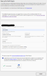
- Fill this out with your information using this link .
Note:It usually takes 1-2 days for Google to approve your account.
- After confirming that your account is activated, you can now access the code editor here.
Tutorial
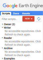
- You will first need to create a new repository using the big red “NEW” button. This will allow you to save scripts and folders.
- After creating a repository, you can now create a new script file using the same “NEW” button.
- Now that you have a repository and a script, you can start the tutorial.
Defining a Study Area
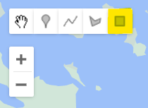
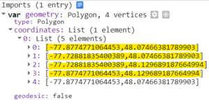
Using the “Draw a rectangle tool”, you can select a study area and copy or change the coordinates in the following code.
//Define study area
var region = ee.Geometry.Polygon([[-77.8778204291992,48.07440799600473],
          [-77.72813170849608,48.07440799600473],
          [-77.72813170849608,48.12989193903527],
          [-77.8778204291992,48.12989193903527]]);
Note:You only need the first four set of coordinates.
