Difference between revisions of "Visualizing Multi-Temporal Data with Time Manager"
| Line 163: | Line 163: | ||
*Mission Accomplished! |
*Mission Accomplished! |
||
<br/> |
<br/> |
||
| − | At this point in time, you have learned to utilize |
+ | At this point in time, you have learned to utilize use the following to conduct spatial pattern analysis: |
* Time Manager plugin for QGIS |
* Time Manager plugin for QGIS |
||
* Visualize data with Time Manager |
* Visualize data with Time Manager |
||
Revision as of 11:20, 19 December 2012
Contents
Introduction
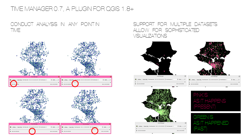
In a distant universe, 500 milliseconds ago, you embarked on a mission of temporal exploration and spatial pattern analysis. Your task is to map and visualize the occurrences of emergencies in the City of Seattle within the month of October and November of the year 2012. You will learn to use learn Time Manager, a plugin for QGIS 1.8; so that you are able to stop any point in time to conduct spatial analysis. Your analysis will be of 1) bi-weekly and 2) monthly emergency occurrences.
Introduction to Time Manager
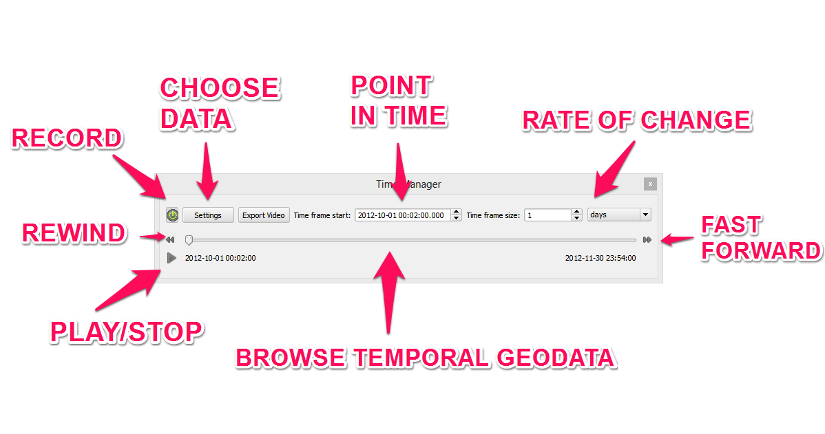
Time Manager is a plugin of QGIS 1.8 that allow for surfing through temporal geospatial data. It is more orientated towards visualization than spatial pattern analysis. Regardless having the ability to go back and forth in time allow for less copies of a single dataset to work with, better organized
Requirements
Windows/Macintosh/Linux Compatible
- A Screenr account.
- Libreoffice 3.6.4 or Openoffice 3.4.1
- QGIS 1.8
- Time Manager plugin for QGIS
- Skitch or Gyazo
Installing Time Manager
Setting Repository
- Start QGIS
- Click "Plugins" on the toolbar. A drop down menu will appear.
- Click "Fetch Python Plugins"
- Click "Repositories"
- Click "Add"
- Name your plugin "Time Manager"
- Type in "https://github.com/anitagraser/TimeManager" in the URL field
- Click "OK" to exit.
Installing Plugin
- Click "Plugins"
- Search "Time Manager"
- Click "Install Plugin" and wait for confirmation of install.
- Click "Close" to exit.
Enabling Plugin
- Click "Plugins" on the toolbar. A drop down menu will appear.
- Click "Manage Plugins"
- Search "Time Manager"
- Enable "Time Manager"
- Click "OK" to exit.
Enabling User Interface
- Time Manager should appear under "Plugins" drop down menu.
- If not, right click on the toolbar, drop down menu will appear; scroll down to Time Manager and check.
- Time Manger should now be at the bottom of your screen.
Getting Data
Getting CSV data
- Proceed to data.seattle.gov
- Search & open Seattle Real Time Fire 911 Calls
- Click "Export", A drop down menu will appear.
- Scroll down to "Download As"
- Download a copy of this dataset in XLSX format
Getting Vector data
- Proceed to data.seattle.gov
- Search & open Street Network Database
- Download a copy of this polyline shapefile in ZIP format
- Search & open Neighbourhoods
- Download a copy of this polygon shapefile in ZIP format
Preparation of Data
Spreadsheet
- Import to Libreoffice or Openoffice or Microsoft Excel
LibreOffice Calc/OpenOffice Calc
- Right click on "datetime" column and proceed to "Format Cells".
- Find and click "User defined" in "Numbers" tab.
- Change format to the following: YYYY-MM-DD HH:MM:SS
- Save file in CSV format.
Microsoft Excel
- Right click on "datetime" column and proceed to "Format Cells".
- Find and click "Custom" in "Numbers" tab.
- Change format to the following: YYYY-MM-DD HH:MM:SS
- Save file in CSV format.
Importing Data
Importing a Spreadsheet to QGIS
- Start QGIS and click "Layer" on the toolbar. A drop down menu will appear.
- Click "Add Delimited Text Layer".
- Browse to location of Seattle_Real_Time_Fire_911_Calls.csv file.
- Click on the "OK" button.
- Right click on the imported spreadsheet on the Layers panel. A drop down menu will appear.
- Click "Save As"
- Format should be "ESRI shapefile"
- CRS should be "WGS84"
- Name of file is "Seattle.shp"
- "Add saved file to map" should be enabled.
- Save file to a desired location.
- Click on the "OK" button.
Importing a Vector Polyline/Polygon to QGIS
- Start QGIS and click "Layer" on the toolbar. A dropdown menu will appear.
- Click "Add Vector Layer".
- Browse to location of your "Seattle.shp" file.
- Click on the "Open" button to import.
Importing a Single Dataset to Time Manager
- Click on the "Settings" button.
- Click "Add Layer".
- Choose "Seattle.shp" as the Layer.
- Choose "Datetime" column as the Start Time.
- Click "OK" to confirm and exit.
Visualizing the Distribution of the Type of Emergency
- Right click on seattle.shp, click "properties" from the drop down menu.
- Browse to the "Style" tab.
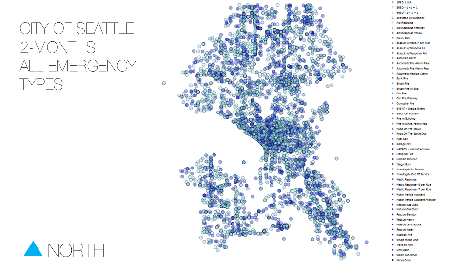
- Change symbology from "Single Symbol" to "Categorized"
- Choose "Type" as the column.
- Pick a gradient color ramp.
- Click on the "Classify" button.
Result: Categorized Symbology
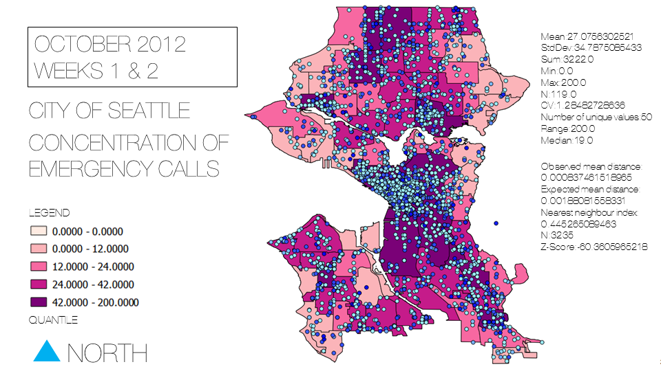
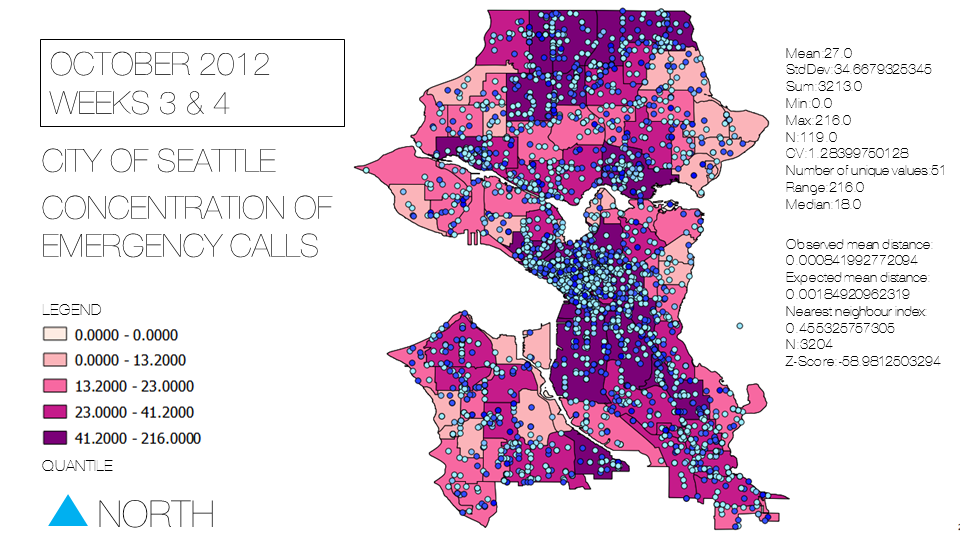
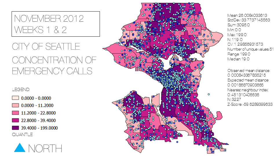
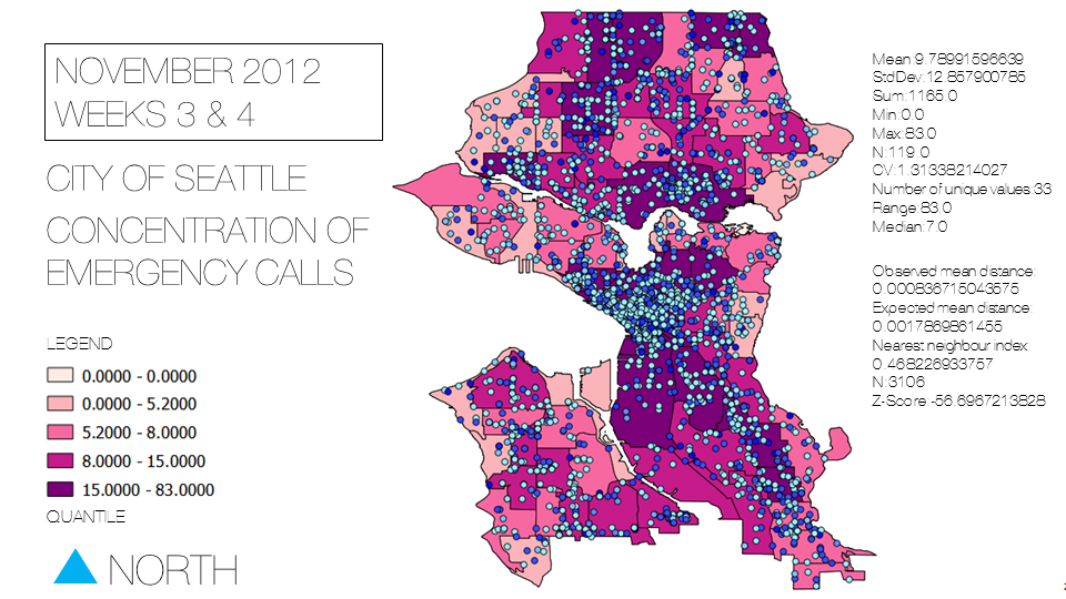
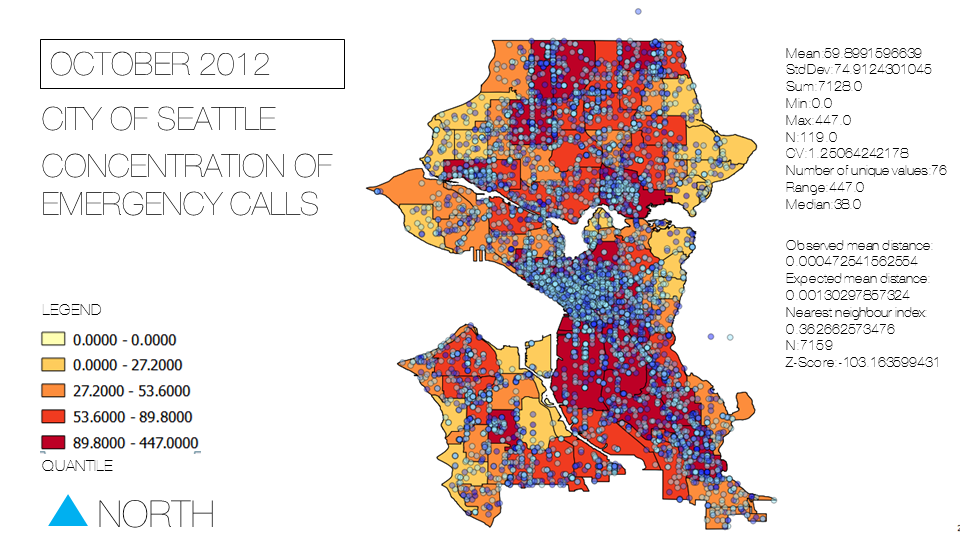
Points in Polygon Spatial Analysis
- Click "Vector" on the toolbar. A drop down menu will appear.
- Click "Analysis" from the drop down menu. Another drop down menu will appear.
- Click "Points in Polygon"
- Choose "Neighbourhoods.shp" as the input polygon vector layer.
- Choose "Seattle.shp" as the input point vector layer.
- Choose a output shapefile name, for this tutorial I chose "area.shp".
- Click "OK" to process.
- Click "Close" afterwards to exit.
Result:Bi-Weekly
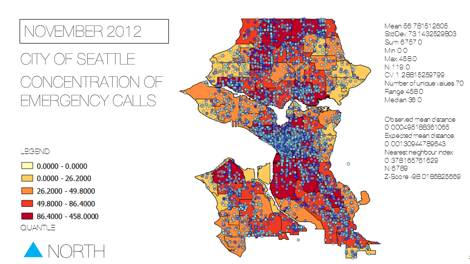
Result:Monthly
Animation with Time Manager
Importing multiple datasets
- Click on the "Settings" button.
- Click "Add Layer".
- Choose "Seattle_Start.shp" as the Layer.
- Choose "Datetime" column as the Start Time.
- Click "OK" to confirm and exit.
- Repeat process with "Seattle_End.shp" as the Layer.
- Change the offset to -20
- Click "OK"
Result: Visualization
Conclusion
- Mission Accomplished!
At this point in time, you have learned to utilize use the following to conduct spatial pattern analysis:
- Time Manager plugin for QGIS
- Visualize data with Time Manager
- Animate/Simulate with Time Manager
- Point in Polygon Analysis
- Nearest Neighbour Analysis
- Basic Statistics such as min, max, median and range.
