Difference between revisions of "User:Abenk"
| Line 1: | Line 1: | ||
==Automatically Calculating USLE using GISus-M== |
|||
=What is USLE= |
=What is USLE= |
||
| Line 22: | Line 22: | ||
Classically, the LS factor was estimated by hand, with complex slopes being broken down into segments. However with the advent of high-resolution open source data, such as South-Western Ontario Orothophotography (SWOOP), LS factor can be calculated through computational means. SWOOP 2010 has a resolution of 20cm and a horizontal accuracy of 50cm, and as such is suitable for calculating the USLE. |
Classically, the LS factor was estimated by hand, with complex slopes being broken down into segments. However with the advent of high-resolution open source data, such as South-Western Ontario Orothophotography (SWOOP), LS factor can be calculated through computational means. SWOOP 2010 has a resolution of 20cm and a horizontal accuracy of 50cm, and as such is suitable for calculating the USLE. |
||
=Study Area= |
|||
A study area in Oxford county was selected with severe dendritic drainage apparent. No sediment control structures such as WASCoBs or grassed waterways were visibly present in the aerial photo. Within the field, there is an approximate 22 metre elevation delta, and the soil type is considered to be a sandy clay loam. As the study area is in Oxford county, the R factor is 100. |
|||
<gallery widths = 300px height = 300 px mode = "slideshow"> |
|||
Image:1.PNG|Field of study outlined in red |
|||
Image:Abenk3.PNG|Elevation of the study area |
|||
The following values are used in calculating the USLE: |
|||
</gallery> |
|||
{| class="wikitable" |
|||
|+USLE Factors |
|||
|- |
|||
|R Factor |
|||
|100 |
|||
|- |
|||
|K Factor |
|||
|0.45 |
|||
|- |
|||
|LS Factor |
|||
|To be calculated |
|||
|- |
|||
|C Factor |
|||
|0.3 |
|||
|- |
|||
|P Factor |
|||
|Varied |
|||
|} |
|||
Constant rasters were created for the R, K, C, and P values for the purpose of this tutorial. |
|||
=GISus-M= |
=GISus-M= |
||
GISus-M was created by the Universidade Federal do Reconcavo da Bahia, and is an add-in for ArcMap that is written in C#. To use the add-in, the user must run the ESRIADDIN file that is contained in the .rar archive. To run GISus-M in ArcMap, one must have prepared all the requisite files for calculating USLE, namely, a raster representing the R, K, LS, and C factors - the P factor is optional and can be included with the C factor. |
GISus-M was created by the Universidade Federal do Reconcavo da Bahia, and is an add-in for ArcMap that is written in C#. To use the add-in, the user must run the ESRIADDIN file that is contained in the .rar archive. To run GISus-M in ArcMap, one must have prepared all the requisite files for calculating USLE, namely, a raster representing the R, K, LS, and C factors - the P factor is optional and can be included with the C factor.[[File:2.PNG|500px|thumb|right|Exampe of the GUI of GISus-M]] |
||
[[File:2.PNG|200px|thumb|left|Exampe of the GUI of GISus-M]] |
|||
Revision as of 17:37, 22 December 2019
Automatically Calculating USLE using GISus-M
What is USLE
The Universal Soil Loss Equation (USLE) allows one to calculate the long-term average soil erosion rates for mainly agricultural lands. When calculating the USLE, five major factors must be taken into consideration:
A = R * K * LS * C * P
Where:
A is the potential long-term erosion rate in tonnes per hectare
R is the rainfall run off factor
K is the soil erodibility factor
LS is the slope length-gradient factor
C is the crop factor
P is the conservation practices factor
Classically, the LS factor was estimated by hand, with complex slopes being broken down into segments. However with the advent of high-resolution open source data, such as South-Western Ontario Orothophotography (SWOOP), LS factor can be calculated through computational means. SWOOP 2010 has a resolution of 20cm and a horizontal accuracy of 50cm, and as such is suitable for calculating the USLE.
Study Area
A study area in Oxford county was selected with severe dendritic drainage apparent. No sediment control structures such as WASCoBs or grassed waterways were visibly present in the aerial photo. Within the field, there is an approximate 22 metre elevation delta, and the soil type is considered to be a sandy clay loam. As the study area is in Oxford county, the R factor is 100.

Field of study outlined in red
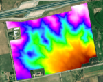
Elevation of the study area
- The following values are used in calculating the USLE:


| R Factor | 100 |
| K Factor | 0.45 |
| LS Factor | To be calculated |
| C Factor | 0.3 |
| P Factor | Varied |
Constant rasters were created for the R, K, C, and P values for the purpose of this tutorial.
GISus-M
GISus-M was created by the Universidade Federal do Reconcavo da Bahia, and is an add-in for ArcMap that is written in C#. To use the add-in, the user must run the ESRIADDIN file that is contained in the .rar archive. To run GISus-M in ArcMap, one must have prepared all the requisite files for calculating USLE, namely, a raster representing the R, K, LS, and C factors - the P factor is optional and can be included with the C factor.
