Difference between revisions of "Traveling Salesman Problem (TSP)"
| Line 10: | Line 10: | ||
OSGeo4w is ''Your Open Source Compass for Windows'' |
OSGeo4w is ''Your Open Source Compass for Windows'' |
||
This package provides a set of open source geospatial software for a Win32 environment. |
This package provides a set of open source geospatial software for a Win32 environment. |
||
| − | Simply follow the directions from this site: [http://trac.osgeo.org/osgeo4w/ Click Here to go to Download Page |
+ | Simply follow the directions from this site: [http://trac.osgeo.org/osgeo4w/ Click Here to go to Download Page] |
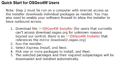
| + | ::[[File:QS.png]] |
||
| − | |||
| + | |||
== Next (1-1.5 hrs)== |
== Next (1-1.5 hrs)== |
||
[http://gracilis.carleton.ca/CUOSGwiki/index.php/Intro_to_GRASS_workshop Launching GRASS Tutorial] This tutorial will give you a simple walk through of GRASS allowing for an increased understanding of the software, though it is not necessary to complete it in full. |
[http://gracilis.carleton.ca/CUOSGwiki/index.php/Intro_to_GRASS_workshop Launching GRASS Tutorial] This tutorial will give you a simple walk through of GRASS allowing for an increased understanding of the software, though it is not necessary to complete it in full. |
||
Revision as of 08:56, 17 December 2012
Contents
Introduction
About the Tutorial
Installation
Firstly (30-60mins)
Firstly you will need to install free geospatial software. This can be found through the secure and trusted site of Open Source Geospatial Foundation OSGeo4w is Your Open Source Compass for Windows This package provides a set of open source geospatial software for a Win32 environment. Simply follow the directions from this site: Click Here to go to Download Page
Next (1-1.5 hrs)
Launching GRASS Tutorial This tutorial will give you a simple walk through of GRASS allowing for an increased understanding of the software, though it is not necessary to complete it in full.
Data
Conclusion
Contributions to This Tutorial
About This Tutorial
This tutorial was created for GEOM4008 which is part of the Geomatics program at Carleton University, located in Ottawa, Ontario, Canada.
External Links
Here is a list of links that offer additional support and information;
- Quantum GIS Web site
- Quantum GIS Wiki
- Grass GIS Web site
- Grass GIS Wiki
- Spatial Reference
References
Data
