Unused files
From CUOSGwiki
Jump to navigationJump to searchThe following files exist but are not embedded in any page. Please note that other web sites may link to a file with a direct URL, and so may still be listed here despite being in active use.
Showing below up to 50 results in range #1,351 to #1,400.
View (previous 50 | next 50) (20 | 50 | 100 | 250 | 500)
 AlbertaDEM 25Mmap.png 572 × 553; 213 KB
 Buildings Attribute.png 166 × 328; 31 KB
 SAGApic8.png 1,212 × 815; 34 KB
 SAGApic18.png 1,474 × 1,012; 41 KB
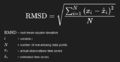 RMSE Formula.png 555 × 286; 21 KB
 Workspace1.png 677 × 226; 42 KB
 Project4.PNG 742 × 569; 59 KB
 Final dem image snaphu.png 1,494 × 663; 103 KB
 QS.png 1,162 × 597; 91 KB
 Adding Layer.jpg 624 × 386; 73 KB
 OttawaPicture.png 1,155 × 894; 1.2 MB
 Image Search for Copernicus Browser.png 446 × 552; 31 KB
 Screenshot 2025-10-01 081520.png 625 × 585; 350 KB
 SubsetAOI.png 624 × 546; 367 KB
 Skitrailosm.png 1,013 × 397; 92 KB
 Skiandgondola.png 1,021 × 397; 107 KB
 Thirdtime.png 1,006 × 393; 78 KB
 Mosaicking.png 558 × 624; 135 KB
 RBGImage.png 869 × 709; 1.74 MB
 SEN2RES.png 369 × 274; 46 KB
 RGB Screenschot.png 687 × 499; 54 KB
 Co-ordinate system.png 1,237 × 849; 129 KB
 Charlottetown watershed coastline.png 739 × 589; 59 KB
 Image 2025-10-05 202325654.png 898 × 589; 42 KB
 Image 2025-10-05 205319955.png 1,151 × 789; 59 KB
 Charlottetown zoning.png 777 × 756; 251 KB
 TT New Layer Creation.png 740 × 618; 198 KB
 TT Quick Time Map.png 1,914 × 154; 76 KB
 Spadina.png 1,026 × 790; 125 KB
 InvalidProj.png 336 × 95; 7 KB
 HighwaysSS.png 989 × 882; 44 KB
 LRTextraction.jpg 998 × 886; 87 KB
 LRTextraction2.jpg 996 × 884; 88 KB
 Layerediting.jpg 33 × 39; 3 KB
 Viastations.jpg 1,325 × 959; 251 KB
 Ottawastation.jpg 1,370 × 881; 143 KB
 Hamburgisochrones done.jpg 2,560 × 1,400; 486 KB
 GEE sign in.png 327 × 221; 13 KB
 Add Layer from GEE.png 537 × 235; 17 KB
 Image4343434332.png 681 × 438; 609 KB
 RasterCalcParam.png 990 × 819; 50 KB
 RasterCalcBox.png 545 × 374; 23 KB
 ClippedVectors.png 751 × 502; 148 KB
 Smart-MapWindow.png 745 × 665; 41 KB
 Hamburglines.jpg 1,581 × 1,254; 206 KB
 Ward19 FacilityCoverage.png 1,267 × 752; 538 KB
 NewFacilitiesBuffered3km.png 1,647 × 916; 1.18 MB
 NewFacilitesLocation.png 632 × 562; 300 KB
 D8FlowAccumulation Tool.png 261 × 392; 17 KB


