Distance Matrix Analysis and Spatial, Non-Spatial and Temporal Querying with QGIS
Contents
Purpose
The objectives of this tutorial are to demonstrate how to convert CSV files to shapefiles, how to complete a Natural Neighbour Analysis using the Distance matrix tool, and how to query using Quantum GIS 2.0.1. This is done by comparing open source data. This tutorial compares Significant Earthquakes from 1990 - 2013 in North America and their relation to Populated Places around the globe. The earthquake data was retrieved from the Significant Earthquake Database on the National Oceanic and Atmospheric Administration Website [1], and the Populated Places data was retrieved from the Natural Earth Website [2].
The Purpose of this tutorial is to fulfill the partial requirements of the GEOM 4008 - Advanced Topics in Geographic Information Systems class' final exam project at Carleton University. The purpose of this project was to explore the advantages and disadvantages of different open source geographic information systems (GIS) programs.
Introduction to Quantum GIS 2.0.1
Quantum GIS 2.0.1 is a free Open Source Geographic Information System (GIS) program that is used to create, edit, visualize, analyze and publish geospatial information (CITE). The program is available for Windows, Mac, Linux, and BSD. This user friendly Open Source GIS program is licensed under the GNU General Public License and is an official project of the Open Source Geospatial Foundation. [3]
QGIS has many different features including QGIS Desktop, where you can create, edit, visualize, analyze and publish geospatial information; QGIS Browser, where you can browse and preview your data and metadata as well as more around your stored data; QGIS Server, where you can publish your QGIS projects as OGC compatible WMS and WFS services; and QGIS Web Client, where you can publish your QGIS projects.[4]
![]()
Downloading QGIS
Before you begin the tutorial, if you do not have the 2.0.1 version of QGIS please follow the steps below:
- Follow this link to download [5]
- Choose which version is compatible with the computer you are working on
- Follow the steps in the popup downloading window
Acquiring the Data
To download the Earthquake data follow these steps:
- Visit the Significant Earthquake Database at this link [6]
- Fill in the date of the form beginning in 1990 and ending in 2013
- Select North America and Hawaii as the Region Name
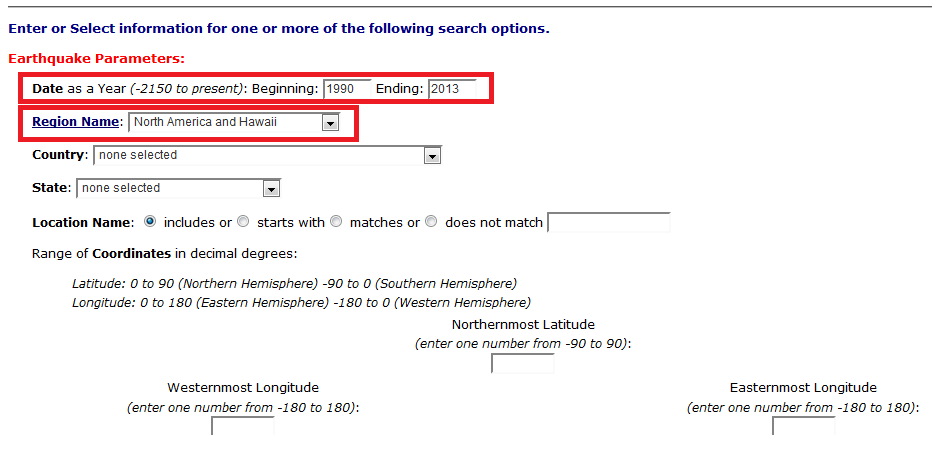
- Select Search Database at the bottom of the page
- copy all features and paste into a text file
- Save to folder

To download the Populated Places data follow these steps:
- Visit the Natural Earth Website at this link [7]
- Click to download the 1.47MB version of the Populated Places.
- Download the file
- Unzip the file
- Save to same folder as the the Earthquake file
Tutorial
Adding CSV File
Once QGIS 2.0.1 opens, start by clicking the Add Delimited Text Layer
