Network Analysis: Finding shortest path in QGIS
From CUOSGwiki
Jump to navigationJump to searchContents
Introduction
Calculating the shortest distance between two points is a commonly cited use for GIS. QGIS ships with this tool, but it’s not visible by default. In this tutorial we will show you what you need to get started.
Data
Acquired QGIS (version 2.6)

Road Graph Plugin
- Activate the Tool
To activate the Road Graph plugin: Start the Plugin Manager by clicking on the QGIS main window’s menu item Plugins ‣ Manage Plugins. A dialog appears. Click OK on the Plugin Manager dialog.
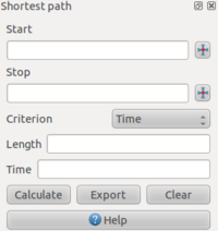
This panel will appear in your interface
If the plugin doesn't show automatically in your interface, go to View ‣ Panels and ensure that Shortest path has a check mark next to it.
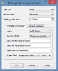
- Configure the Tool
- Use the Tool
- Using Criteria


