Difference between revisions of "Network Analysis Plugins in QGIS, What (and How) to Use"
(→QNEAT3) |
|||
| Line 66: | Line 66: | ||
| − | === Point-to-point routing |
+ | === Point-to-point routing === |
| − | |||
| − | |||
=== Service Area calculation === |
=== Service Area calculation === |
||
Revision as of 13:09, 8 December 2023
Contents
Introduction and Purpose
Network analysis is a common GIS application with real-world uses ranging from determining the most efficient routes for delivering goods to the best location for a transit hub. This tutorial is catered to those who are familiar with QGIS operations.
QGIS
Quantum GIS, commonly referred to as QGIS, is an open source software that boasts a great number of tools and functions to complete various geospatial operations. It is maintained and updated through its large volunteer community, and there are a wealth of online resources available on the QGIS site and the associated documentation page which contains resources like help manuals
APIs
API stands for Application Programming Interface. APIs allow two softwares to communicate with each other. In this tutorial, APIs enable plugins to access different data and tools to conduct network analyses. The reason many of the plugins do not require a local data download to conduct operations (see table under Plugins) is because they are access data from an external server through an API. For more information on APIs, feel free to visit the AWS API resource page.
Learning Outcomes
After completing this tutorial, you will know how to:
- Install a plugin on QGIS
- Register for HERE and TravelTalk APIs
- Conduct Point-to-point network analysis using QNEAT3, Online Routing Mapper, TravelTime, and Hqgis
- Do Service Area calculations with QNEAT3, TravelTime, and Hqgis
- Geocode addresses using TravelTime and Hqgis
- Run a POI search with Hqgis
Plugins
Several plugins have been created to support or enhance the functionality of QGIS. Each plugin has different benefits and limitations, so be sure to familiarize yourself with your project to make sure you make the right selection. For example, using an API may be preferred to reduce processing times as calculations are being completed on external servers. On the other hand, you will have to plan ahead to use APIs that require accounts to generate permission keys, as it can take some time for your account to gain access. The table below shows the different functions each plugin offers to help with your selection. For more information on a particular plugin, click the embedded link.
| Plugin | Local Data Required? | Functions | API Login required? | Notes |
|---|---|---|---|---|
| QNEAT3 | Yes | Point-to-point routing, Service Area calculation, Origin-Destination matrix | No | Origin-Destination matrix does not generate |
| Online Routing Mapper | No | Point-to-point routing | No | Only HERE and TomTom APIs remain supported |
| TravelTime | No | Point-to-point routing, Service Area calculation, Geocoding | Yes | Slow API account validation, limited number of data queries on free account |
| Hqgis | No | Point-to-point routing, Service Area calculation, Geocoding, POI search | Yes | Limited number of API keys generated for each project |
Tutorial
QGIS
This tutorial uses QGIS, if you have yet to install the software, follow this link to do so. This tutorial uses QGIS 3.32. Select the version you wish to download based on your operating system, and follow the guide that is installed in the package. Once QGIS is installed, launch the application to begin the tutorial.
Installing Plugins
There are many plugins available in QGIS, but they must be installed before you can use them.
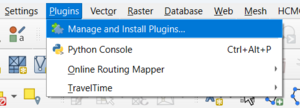
- To access plugins, click the Plugins tab in the menu, then select Manage and Install Plugins... This will open a pop-up window.
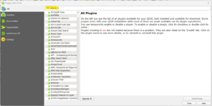
- At the top of the new window, you will see a search bar (highlighted in yellow), and a list of all available plugins below it.
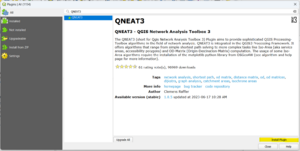
- Search for QNEAT3 using the search bar, and select the result. A brief description will appear in the right hand side of the window. Next, click the Install Plugin button (highlighted in yellow) to install.
- Repeat this process for the Online Routing Mapper, TravelTime, and Hqgis plugins.
QNEAT3
QNEAT3 is similar to the default network analysis tools in QGIS, as both are able to do point-to-point routing, do service area calculations, and require a network file to either of these analyses. However, QNEAT3 offers a different visualization of the outputs, with routes extending off the network if the start or end point lies outside the network, and showing service areas as either contours, polygons, pointclouds, or buffers, while the default QGIS tool depicts the service area by highlighted network segments within the area.
Data
The data used in this tutorial is the Trois-Rivières road network found using the Government of Canada's Open Government Portal. It can be found and downloaded by following this link and selecting the SHP file option. *image of govt geoportal


