Tropical Flood Mapping and Area Calculation of Flood Extent Using Sentinel-I SAR Data in Google Earth Engine: the case of Super Typhoon Odette (Rai)
Contents
- 1 Introduction
- 2 Setting up Google Earth Engine
- 3 Tutorial
- 3.1 Preparing your data
- 3.2 Step 1. Selection of Study Area
- 3.3 Step 2. Setting the time frame
- 3.4 Step 3. Selection of Sensor Parameters
- 3.5 Step 4. Running the script
- 3.6 Step 5. Visualizing Results in Google Earth Engine
- 3.7 Step 6. Exporting generated products
- 3.8 Step 7. Refining the Flood Extent layer
- 3.9 Step 8. Area calculation of flood extent
- 4 Conclusion
- 5 References
Introduction
Purpose and Overview
This tutorial aims to produce a map showing the flood extent of the affected areas. This can be achieved by building scripts to gather satellite images taken before and after a flood event and comparing them. Google Earth Engine provides large-scale visualization and analysis of geospatial data, particularly Sentinel-I SAR GRD imagery. This approach is used due to its resistance to weather and cloud cover; thus, it is a reliable way to detect flooded regions.
The Google Earth Engine (GEE) is a free, planetary-scale platform software used for educational and operational research and non-profit use. This open software developed by Google has been used to operate various studies on a global and regional scale, including Land Use and Land Cover (LULC), flood mapping, surface water mapping, and other applications.
Flood mapping is important especially in tropical regions because these areas are prone to typhoons and cyclones and are usually surrounded by open waters. This is crucial during the immediate response phase to make decisions on evacuations, calculating the extent of damages, and appropriate deployment of aid for the victims.
Area of Interest
On December 16, 2021, a super typhoon Odette or Rai, as named internationally, severely affected the Visayas and Mindanao group of islands in the Philippines. This typhoon fell on a Category-5 scale and was considered as one of the strongest storms that struck the country.
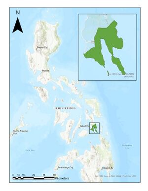
In this tutorial, the area of interest will be in the province of Southern Leyte, located in the Eastern Visayas Region of the Philippines. This area is chosen because there were not a lot of GIS articles written about this phenomenon, since it only occurred a week ago. In this way, the flood extent of Southern Leyte will be determined while learning how to generate it using Google Earth Engine.
Setting up Google Earth Engine
Google Earth Engine is a web-based integrated development environment (IDE) for JavaScript API and a cloud-based geospatial procession platform. To make sure that working in this software is fast and easy, you should have a Google Earth Engine account.
Creating an account
- Go to https://signup.earthengine.google.com/ and sign up with your Google account. You can also use your existing Gmail account to sign-up.
Note: This step usually takes 1 - 2 days for approval. Do this as soon as possible.
- After approval, you will receive an email from Google that you are all set up.
- Then, go to https://code.earthengine.google.com/ to start coding!
To ensure a hassle-free sign-up process, follow these tips:
- Use Google Chrome browser.
- If you have multiple Google accounts, make sure that you are logged in to the account that you want to be associated with Earth Engine.
Components of Google Earth Engine Code Editor
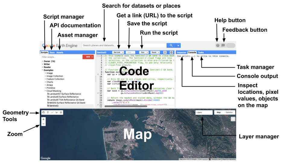
After going to the website, you should see the entire components of the Earth Engine Code Editor:
Setting up your repository
You need to create your Owner repository folder to be able to save your codes and files. To do this:
- Click the NEW button on the right side of the editor.
- Click Repository.
- Write a repository name of your choice. It must be unique, and you cannot change it later.
- When you save your scripts later, they will be saved under the Owner section.
Tutorial
Preparing your data
To prepare your data, follow these steps:
- Download the shapefile of the Philippine administrative area in GADM here.
- Choose Philippines in the country drop-down menu.
- Click Shapefile. The zip file download will start automatically.
- In your Downloads file location, extract the zip file into a different folder by right-clicking it and choosing Extract to gadm36_PHL_shp/. There should be a folder in the same location.
Note: You will only need Level 1 shapefiles for this tutorial.

