Landscape Structure Analysis Using the Landscape Patch Analysis Toolset in GRASS GIS
Contents
Introduction to Landscape Patch Analysis
Landscape Ecology
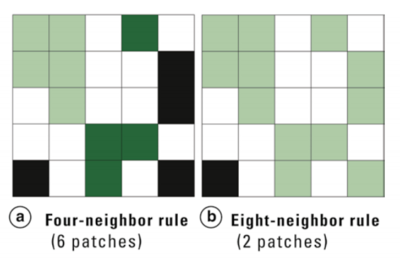
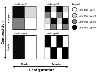
Landscape ecology is the field of study concerned with determining the spatial patterns and spatial pattern change in terms of landscape structure. Landscape structure refers to the organization of the landscape in terms of its spatial heterogeneity. There are two aspects of spatial heterogeneity that we can examine through landscape structure analysis; composition and configuration. Composition refers to the different elements of a landscape. Configuration refers to the spatial arrangement of the elements, see Figure 1. Based on these elements, spatial heterogeneity or homogeneity can be construed by examining patches in the structure statistically.
Patches are areas of homogeneous land cover; they can be examined for spatial patterns and statistical measures which are telling of structure. The landscape can then be evaluated in terms of the impact of structure on ecological phenomenon and ecosystems.
The value in examining the configuration and composition of landscapes is to have a greater understanding of the factors influencing ecosystem health in a statistically valid way, awareness of possible detriments to species, and the ability to examine patterns in a given landscape at varying degrees of complexity (grain and extent).
Methods in Landscape Structure Analysis
Landscape ecology methods in this tutorial....
- patch density.... - patch number.... - mean patch size.... - edge density...
- Shannon diversity....
Data for Tutorial
Landscape structure analysis is performed on classified data....
The classified .tif file that was used in this tutorial can be downloaded from Dropbox at the following link: https://www.dropbox.com/s/8tvj9psf29zmxah/ClassifedImage.tif?dl=0
This file was produced in Focus (PCI Geomatica) by running a supervised classification on a corrected satellite image of Gatineau Park. The classes used for the classification were forest, water, exposed rock and soil, developed areas, and areas of short vegetation. These are relatively simple and easily separable classes.
Tutorial Methods
Starting up GRASS GIS and Setting up the Database
Launch GRASS GIS 7.6.1.
If you are starting GRASS GIS for the first time on your computer you may see a notice appear addressing this. Select "OK" when you have read it.
GRASS requires that a database be created where files can be stored in a GRASS-specific hierarchy formats. The GRASS GIS 7.6.1 Startup window prompts you to set up a database directory.
In the first section, create and browse to a folder called "GRASS_GIS".
In the second section, create a new location by selecting "New" and name the location "Landscape". Select "Next".
The data in this location will all use the same spatial reference system; which you specify in the this window. Choose the option "Read projection and datum terms from a georeferenced data file". Select "Next" and in this window navigate to the location where the Landscape Patch Analysis data you downloaded is saved. Select the ***********classified_landscape********** file. Select "Next", then "Finish". Select "Yes" when prompted as to whether the selected layer should be imported into the database.
In the GRASS GIS 7.6.1 Startup window, single-click the "Landscape" location and single-click on "PERMANENT" in the third section.
Select "Start GRASS session".


